


sucs des Chartreux

NADINE52
User
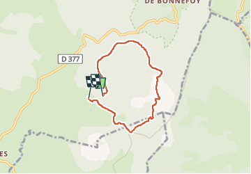

Length
5.6 km

Max alt
1585 m

Uphill gradient
190 m
Km-Effort
8.1 km

Min alt
1433 m

Downhill gradient
161 m
Boucle
No
Creation date :
2022-09-08 07:34:21.102
Updated on :
2022-09-08 10:09:42.757
1h43
Difficulty : Medium

FREE GPS app for hiking
 SityTrail
IGN / Geographical institutes
SityTrail Plus
The world is yours!
About
Trail Walking of 5.6 km to be discovered at Auvergne-Rhône-Alpes, Ardèche, Le Béage. This trail is proposed by NADINE52.
Positioning
Country:
France
Region :
Auvergne-Rhône-Alpes
Department/Province :
Ardèche
Municipality :
Le Béage
Location:
Unknown
Start:(Dec)
Start:(UTM)
591425 ; 4967335 (31T) N.
Comments